What a trek to choose? - Total cost and complexity
 To select a foreign campaign, in addition to their own aesthetic preferences should take into account two important factors - the complexity of the route and the total cost of the event. The complexity of the route affected - the duration of the campaign, the nature of the relief, the quality of trails, altitude, weather conditions, the weight of the backpack (create zabroski), the availability of technical areas. The total travel cost is the cost of the tour, tickets and local spending. And I must say, the results of the addition are impressive :) Tsiferki (ie prices) can be easily boiled down to a table comparing the costs (see below), but the particular routes, determining their complexity, it was necessary to describe the words (more below). I sincerely hope that you are not afraid of difficulties, and this text will help you better prepare for them and more consciously choose a hike (and not bring the idea to hide under the bed and nowhere to go).
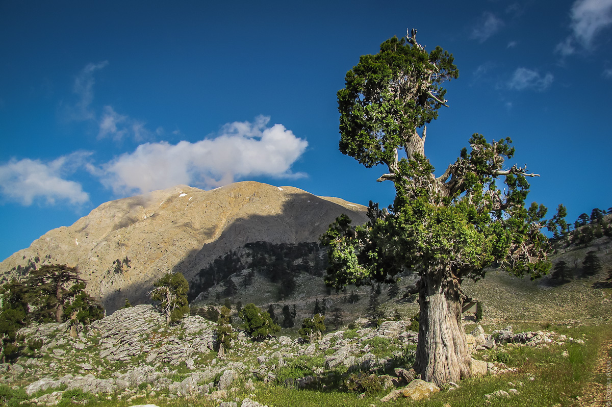
Lycian Way (Turkey)
Route
guest
Video
Photo Album
According to the complexity of the route is very close to the Crimean campaigns of similar duration. We live in tents, cook over a campfire, all drag on itself, in backpacks. But the route is the ability to replenish food stocks, so backpacks are relatively light - not everyone gets to 9-10, but only 4-5 kg of food. In spring (April-early May) in Turkey is quite comfortable for hiking. Here is warmer than in the Crimea in the same period. Happy is not too hot (20), the night is not cold (+10). But do not relax when the rains come, in the highlands of sharply colder (by day 15, the night 0). Maybe even sprinkle snow. But it is necessary to go down to the sea, as adjusted life again. Sea, by the way, warm - you can swim. During the summer and early fall on the Lycian trail is usually very, very hot. Springs dry up, rivers are hiding under rocks, tourists languishing in the heat (35 day 20 night). Vital sunscreen, panama and shirts with long sleeves. On the "Lycian Trail" no off-road - the route is entirely on good trails and dirt roads. Only the top of the climb Tahtalı will land with boulders and early spring, there may be snow fields that are easily overcome, even in running shoes - thick snow, last year. But on a long descent from the pass Tahtalı many knees.

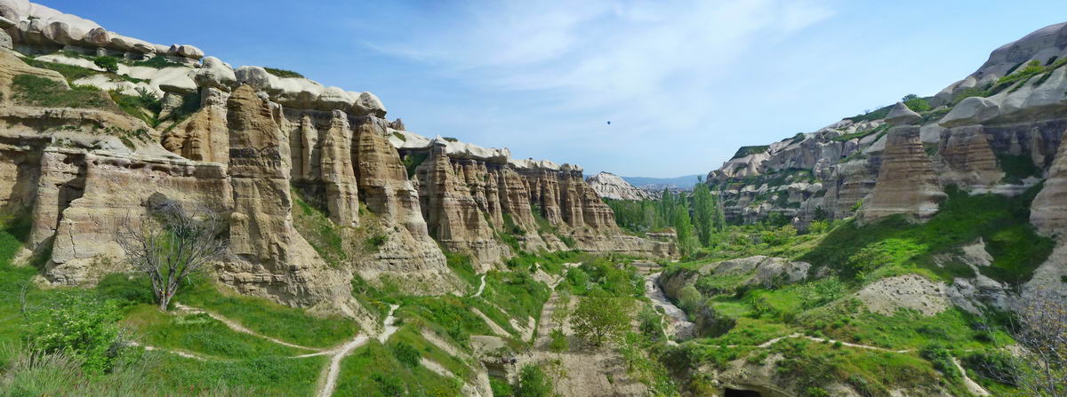
Unreal Cappadocia (Turkey)
Route
Video
Photo Album
This tour is usually an addition to the previously described "Lycian trail." We live in a hostel (a common room for 10-15 beds) with a hot shower and the other joys of life. Zavtrkaem at the hostel, dine in restaurants, have dinner with dry rations. Every day we go on long "Radialka" (6-8 pm). Go easy with small rucksacks (water bottle, rain gear, lunch ration). At +25, +7 night.
The trails are great.

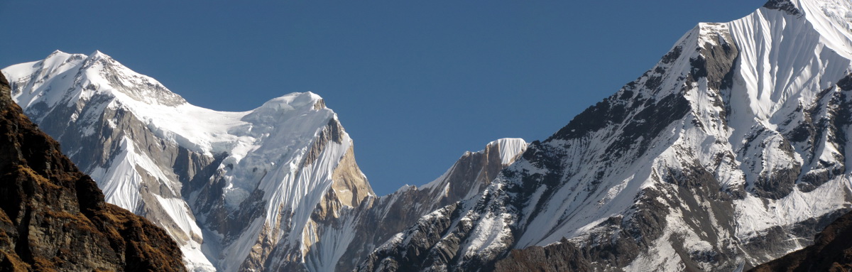
To the heart of the Annapurna (Nepal)
route to the heart
guest
Videos < / a>
Photo Album
This is the affordable way to see the Himalayas. The route is simple enough to try to pass it they have had a few experiences of the Crimean campaigns. We spend the night in the mountain shelters - lodges, eat in the same place, so the tents, mats, food, pots and other drag is not necessary. With only a bear clothes and sleeping bags. The average weight of 10 kg backpack. However, even it can not bear a hire porter (20 kg it is $ 14 per day).
2/3 of the track to the Annapurna Base Camp is held by "comfortable jungle" - by day 25, 10 at night, around rice fields and rhododendron jungle. 3 days and 2 nights we spend in the cold mountainous area where the 15 day, and at night 0. It was during these three days you have all the chances to meet gornyashka - headache, weakness, nausea, etc. But if it gets too bad you can always fall back - go down to the place of the previous overnight and there at the shelter waiting for the return of the group.
The trails are very good, often paved with stone slabs. But the endless descents and ascents, these stone steps could significantly undermine the psyche and load the knees :) I do not think that this route - a solid "ball". Due to lack of oxygen and decent changes in elevation, even stomping with light backpacks, or none at all, you'll be tired and exhausting.

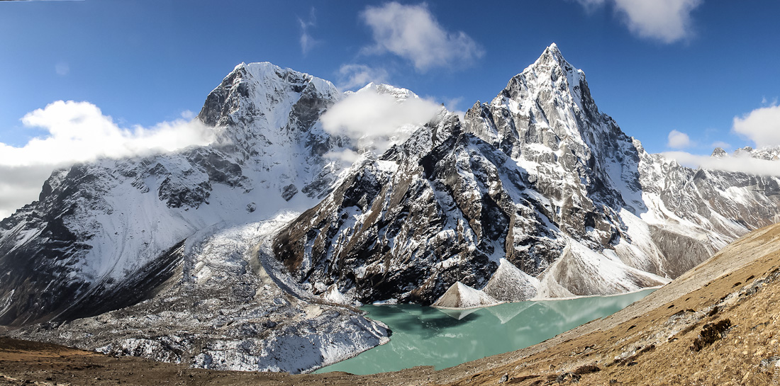
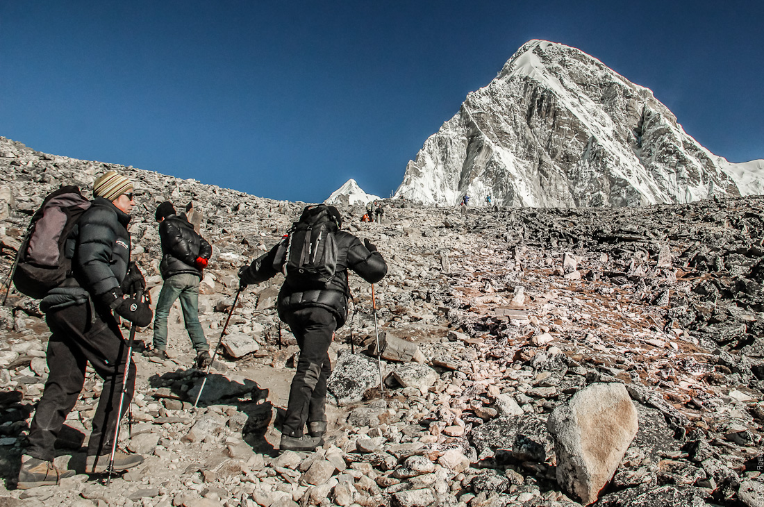
Trekking to Everest (Nepal)
Route
Medical contraindications
gornyashka
In contrast to the previous track, the route to Everest Base Camp at 100% passes through a cold mountainous area (10 day -5 at night). Here you can not meddle with no high-rise experience (at least 3,500), not knowing how much your body otregiruet a lack of oxygen. Someone will twist on the second day, someone will be so good in a week - but sooner or later, "will cover" each. At these altitudes, a person constantly feel cold, even if the air temperature is far from extreme. Common cold can easily be transformed into a dangerous inflammation of the lungs. Therefore, on the track to Everest vital warm winter sleeping bag, down jacket, good shoes, underwear and other means of insulation. Accommodation in lodges and feeding. The number of personal items are strictly limited - 14kg (because of the flight to Lukla). Minimizarovat to load (and risk) in any case we are hiring porters. Chances contingency (the helicopter in case of bad weather). The whole difficulty of the route to Everest lies solely in the lack of oxygen - trails here for the most part are great (and trodden flat), but the pass is a difficult area.

Jade Dragon (China)
Route
guest
Photo Album
Very civilized route - we live in decent hostels (with hot water, bed linen and Wi-Fi), eat in restaurants, go on an extreme ennobled routes. Of equipment are only cameras and backpacks (that was where to put souvenirs). The main factors of "hardship" tour in China - a crazy event density, constant flights and transfers (and the consequent lack of sleep), and the very very large sum of financial costs. Weather in China have met very different - from the warm subtropics (30) to the alpine tundra (+5).
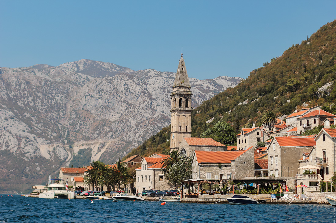
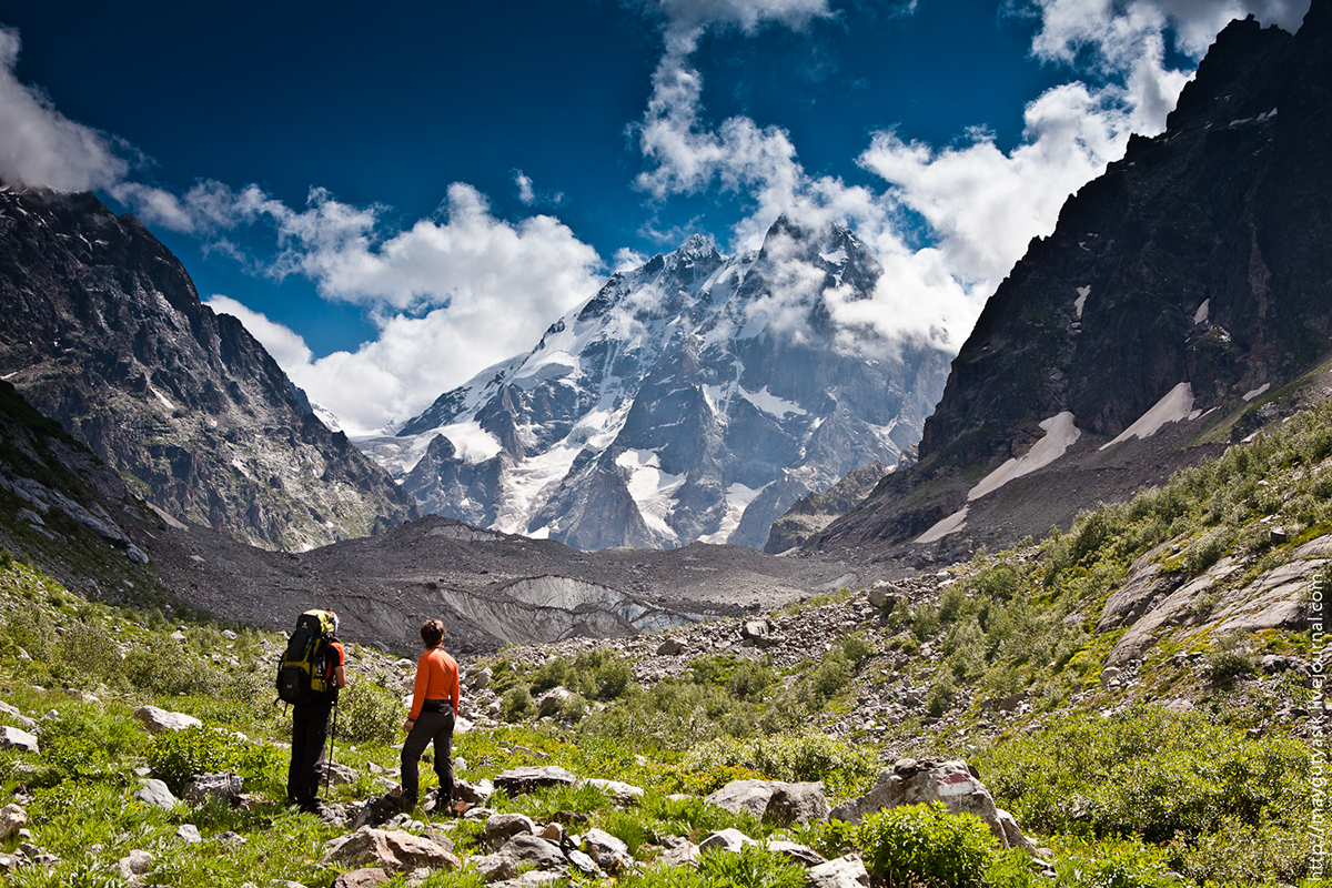
Prokletije Durmitor (Montenegro)
Route
guest
Video
Main "zamanuhi" of the route - the warm sea and steep cliffs. With them are connected and the main difficulties of this campaign - the hot climate and difficult terrain. In the afternoon air can be heated up to +30, frequent forest fires, at night the temperature drops sharply to +7 (need warm clothes required). On the route of many areas with large boulders and diversiform sypuhoy. There are places (Radialka on Karanfily and Bobotov Cook), where you have to cling to his hands full. Visually impressive look many passes (that's cool gaining height). Anyway daily climb on this route consistently high (not less than 600 meters). Comparatively speaking, hiking in Montenegro is technically more difficult than the same Lycian Way in Turkey. But backpacks are not too heavy (products for the second half trek to re-buy on the spot) and a lot of radialok (at least 5), where we walk light. We sleep in tents, cook on the burner.


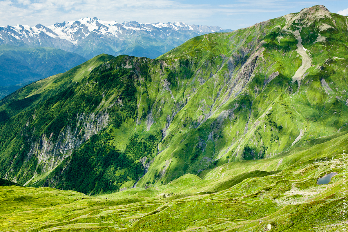
Upper Svaneti (Caucasus, Georgia).
Route
For such paths is a pleasure to pass on the 20 km per day. Daily climb from 800 to 1500 meters (that much). Not to mention about the cultural dimension of travel - medieval villages, impressive Svan towers, colorful local population. It is possible to make zabrosku, which greatly facilitates the backpack, because it is necessary to carry not only products, but also fuel for the burner. On the route will be a couple of crossings of mountain streams and rivers. Some of them we overcome jumping over rocks, well, boosting the biggest on horseback (from a neighboring village).
Hike to Mount Kazbek (Caucasus, Georgia).
Route
This short route - the same addition to shopping Svaneti as Cappadocia to Lycian trail. Please note that this is not climbing, do not climb to the top of Mount Kazbek, and a hike to a height of 4300m. Height, by the way, is quite sufficient to form some idea of the mountain illness. Part of the route runs right through the glacier, on the part of the mud-caked snow, so as shoes for a hike on Mount Kazbek preferred shoes (not sneakers). Night on the three-kilometer altitude pretty cold can be "minus" - will not prevent a warm sleeping bag, gloves, hat.

Climbing Elbrus from the North . (Caucasus, Russia).
Route
Equipment list
Average climber climbing, with all the attendant joys of life. Wildly heavy backpack at the start, and almost empty backpack on top. Permanent acclimatization running up and down the same places that somehow tame the inevitable gornyashka. Among other things you will need special equipment - cats, ice ax, these mountain boots (you can "plastic"), a winter sleeping bag, down jacket. We live in tents, cook on a primus stove ... Very tough day of climbing - 1900 meters of climbing, 10:00 for the summit, 3:00 on the descent. The temperature at the bottom of the 25, and -10 on the night of the assault.


Trans-Ili Alatau (Tien-Shan Mountains, Kazakhstan).
Route
It's a new route, which means there will be many surprises. The actual level of complexity is difficult to predict, so we will consider it high. On the route there will be many sypuhi and off-road - there can not do without shoes. They also come in handy when go through the glacier, or when the mountains prisypet fresh summer snow. Expected daily evening thunderstorms. Height passes and nights is sufficient for primary acquaintance with altitude sickness. Getting to be like without it :)
Now that you know how to choose a foreign campaign? If you still have questions, please write or call us - we will help you choose a suitable route
Kirill Yasko, June 2013.
This tour is usually an addition to the previously described "Lycian trail." We live in a hostel (a common room for 10-15 beds) with a hot shower and the other joys of life. Zavtrkaem at the hostel, dine in restaurants, have dinner with dry rations. Every day we go on long "Radialka" (6-8 pm). Go easy with small rucksacks (water bottle, rain gear, lunch ration). At +25, +7 night.
The trails are great.
To the heart of the Annapurna (Nepal)
route to the heart
guest
Videos < / a>
Photo Album
This is the affordable way to see the Himalayas. The route is simple enough to try to pass it they have had a few experiences of the Crimean campaigns. We spend the night in the mountain shelters - lodges, eat in the same place, so the tents, mats, food, pots and other drag is not necessary. With only a bear clothes and sleeping bags. The average weight of 10 kg backpack. However, even it can not bear a hire porter (20 kg it is $ 14 per day).
2/3 of the track to the Annapurna Base Camp is held by "comfortable jungle" - by day 25, 10 at night, around rice fields and rhododendron jungle. 3 days and 2 nights we spend in the cold mountainous area where the 15 day, and at night 0. It was during these three days you have all the chances to meet gornyashka - headache, weakness, nausea, etc. But if it gets too bad you can always fall back - go down to the place of the previous overnight and there at the shelter waiting for the return of the group.
The trails are very good, often paved with stone slabs. But the endless descents and ascents, these stone steps could significantly undermine the psyche and load the knees :) I do not think that this route - a solid "ball". Due to lack of oxygen and decent changes in elevation, even stomping with light backpacks, or none at all, you'll be tired and exhausting.
Trekking to Everest (Nepal)
Route
Medical contraindications
gornyashka
In contrast to the previous track, the route to Everest Base Camp at 100% passes through a cold mountainous area (10 day -5 at night). Here you can not meddle with no high-rise experience (at least 3,500), not knowing how much your body otregiruet a lack of oxygen. Someone will twist on the second day, someone will be so good in a week - but sooner or later, "will cover" each. At these altitudes, a person constantly feel cold, even if the air temperature is far from extreme. Common cold can easily be transformed into a dangerous inflammation of the lungs. Therefore, on the track to Everest vital warm winter sleeping bag, down jacket, good shoes, underwear and other means of insulation. Accommodation in lodges and feeding. The number of personal items are strictly limited - 14kg (because of the flight to Lukla). Minimizarovat to load (and risk) in any case we are hiring porters. Chances contingency (the helicopter in case of bad weather). The whole difficulty of the route to Everest lies solely in the lack of oxygen - trails here for the most part are great (and trodden flat), but the pass is a difficult area.
Jade Dragon (China)
Route
guest
Photo Album
Very civilized route - we live in decent hostels (with hot water, bed linen and Wi-Fi), eat in restaurants, go on an extreme ennobled routes. Of equipment are only cameras and backpacks (that was where to put souvenirs). The main factors of "hardship" tour in China - a crazy event density, constant flights and transfers (and the consequent lack of sleep), and the very very large sum of financial costs. Weather in China have met very different - from the warm subtropics (30) to the alpine tundra (+5).
Prokletije Durmitor (Montenegro)
Route
guest
Video
Main "zamanuhi" of the route - the warm sea and steep cliffs. With them are connected and the main difficulties of this campaign - the hot climate and difficult terrain. In the afternoon air can be heated up to +30, frequent forest fires, at night the temperature drops sharply to +7 (need warm clothes required). On the route of many areas with large boulders and diversiform sypuhoy. There are places (Radialka on Karanfily and Bobotov Cook), where you have to cling to his hands full. Visually impressive look many passes (that's cool gaining height). Anyway daily climb on this route consistently high (not less than 600 meters). Comparatively speaking, hiking in Montenegro is technically more difficult than the same Lycian Way in Turkey. But backpacks are not too heavy (products for the second half trek to re-buy on the spot) and a lot of radialok (at least 5), where we walk light. We sleep in tents, cook on the burner.
Upper Svaneti (Caucasus, Georgia).
Route
For such paths is a pleasure to pass on the 20 km per day. Daily climb from 800 to 1500 meters (that much). Not to mention about the cultural dimension of travel - medieval villages, impressive Svan towers, colorful local population. It is possible to make zabrosku, which greatly facilitates the backpack, because it is necessary to carry not only products, but also fuel for the burner. On the route will be a couple of crossings of mountain streams and rivers. Some of them we overcome jumping over rocks, well, boosting the biggest on horseback (from a neighboring village).
Hike to Mount Kazbek (Caucasus, Georgia).
Route
This short route - the same addition to shopping Svaneti as Cappadocia to Lycian trail. Please note that this is not climbing, do not climb to the top of Mount Kazbek, and a hike to a height of 4300m. Height, by the way, is quite sufficient to form some idea of the mountain illness. Part of the route runs right through the glacier, on the part of the mud-caked snow, so as shoes for a hike on Mount Kazbek preferred shoes (not sneakers). Night on the three-kilometer altitude pretty cold can be "minus" - will not prevent a warm sleeping bag, gloves, hat.
Climbing Elbrus from the North . (Caucasus, Russia).
Route
Equipment list
Average climber climbing, with all the attendant joys of life. Wildly heavy backpack at the start, and almost empty backpack on top. Permanent acclimatization running up and down the same places that somehow tame the inevitable gornyashka. Among other things you will need special equipment - cats, ice ax, these mountain boots (you can "plastic"), a winter sleeping bag, down jacket. We live in tents, cook on a primus stove ... Very tough day of climbing - 1900 meters of climbing, 10:00 for the summit, 3:00 on the descent. The temperature at the bottom of the 25, and -10 on the night of the assault.
Trans-Ili Alatau (Tien-Shan Mountains, Kazakhstan).
Route
It's a new route, which means there will be many surprises. The actual level of complexity is difficult to predict, so we will consider it high. On the route there will be many sypuhi and off-road - there can not do without shoes. They also come in handy when go through the glacier, or when the mountains prisypet fresh summer snow. Expected daily evening thunderstorms. Height passes and nights is sufficient for primary acquaintance with altitude sickness. Getting to be like without it :)
Now that you know how to choose a foreign campaign? If you still have questions, please write or call us - we will help you choose a suitable route
Kirill Yasko, June 2013.
It's a new route, which means there will be many surprises. The actual level of complexity is difficult to predict, so we will consider it high. On the route there will be many sypuhi and off-road - there can not do without shoes. They also come in handy when go through the glacier, or when the mountains prisypet fresh summer snow. Expected daily evening thunderstorms. Height passes and nights is sufficient for primary acquaintance with altitude sickness. Getting to be like without it :)
Now that you know how to choose a foreign campaign? If you still have questions, please write or call us - we will help you choose a suitable route Kirill Yasko, June 2013.