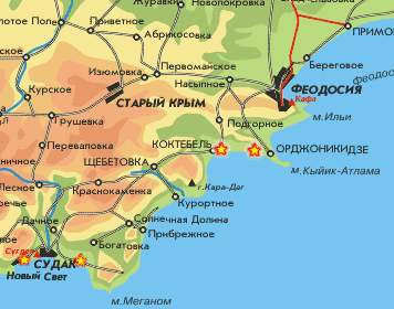
Crimea Maps
Plan of railway station Simferopol
During a resort season the railway station of Simferopol is similar to the raging sea. Thousand people daily come and leave from here by trains, buses and trolley buses. And much of them do not have no simple thing - the plan of the Simferopol station. Here we today also shall publish it.Map of Evpatoria
Map of the city of Evpatoria (170kb). On a map there is all that is necessary for the true Indian - the station and Black sea is designated. As the free supplement the basic streets are signed.Detailed map of Evpatoria (997kb). It is a detailed map of the center of Evpatoria more precisely. Houses on a map of unusual crimson color, but are signed all streets and lanes.
Map of Alushta
Map of Alushta (180kb) nice map, gives approximate representation about Alushte and vicinities. Big streets are signed only. But unlike tourist schemes it is really map - at it the North from above, as well as is necessary!!!Scheme of Alushta (500kb.) has the alphabetic list of streets. On a sheme hotels, sanatoria and boarding houses Alushty are designated. Quality of a picture low.
Plan of Alushta (315kb). This plan is obviously made on the basis of the previous map. Have slightly cleaned appearance, have added pictures of boarding houses and phones of various urban services Alushty: militias, first aid, help, gorispolkomai etc.
A map of Alupka
A map of Alupka (866kb) is the Very variegated tourist chart of Alupka. Scanned not very much high-quality, shallow inscriptions are heavily read therefore. On a map: sights, hotels, names of basic streets, transport, public catering and rest rooms, are marked.A chart of Alupka (87кб) is Much more simple and easy-to-read chart. Here only the names of streets and cutting in with the center of city. On her, by the way, besides traditional cafes, hotel, library and mail marked a red color certain Unknown object. What it would be...?
Map of Yalta
Actually in this section not one map of Yalta, but 4. For all tastes, so to say. From the elementary scheme(plan) of streets, up to a detailed map of city.Map of Crimea
In this section I have collected references(links) to the best maps of Crimea. These are maps scanned and digital. In general all that can be necessary for the confident orientation in Crimea.The Map of clothing-optional beaches of Crimea
 On this map beaches in district of Feodosiya, the Pike perch and New Light are put(rendered). And up to beaches in vicinities(environs) of the Pike perch and New Light I have found out road on one of forums: " In the Pike perch if to pass(take place) on embankment aside Feodosiya and to round on rocks headland Alchak (in one place it is necessary to keep for the cable attached to a rock, but anything, everyone pass(take place)) it is possible it is lonely pozagorat on in rocks at water, having chosen a flat stone. To float it is necessary cautiously: a rocky bottom(fundus). If to take with itself a mask it is possible to catch rapanov.
How to get - Kazantip map
The easiest way is to fly to Simferopol International airport where you then make your way to KaZantip. You can also fly first to Kiev then make your way to Simferopol by plane or train. At Simferopol we will meet you and ensure you get to KaZantip without delay. We recommend that you book your trip trough a travel agency with experience in dealing with Ukraine.The Map of Feodosiya
 the Map of Feodosiya with names of streets and the list dostoprimetsatelnostej.
This map - most rasprostrannennaja on the Internet a map of Feodosiya, probably because the best. She not too motley so it will be good to be read at a press(seal) on the black-and-white printer.
Download a map of Feodosiya (376 kb)