

In 10 days we will go around Mont Blanc (4810 m, the highest peak of the Alps) and pass through the territory of France, Italy and Switzerland. The maximum altitude on the route is 2660 meters. This trek does not require the use of special equipment, we simply follow the trails. Nevertheless, it will not be easy - every day we storm a new pass, gain and lose at least 500 meters of altitude. All overnight stays are in tents. In case of bad weather, you can stay under a roof, in a shelter.
Hiking plan.
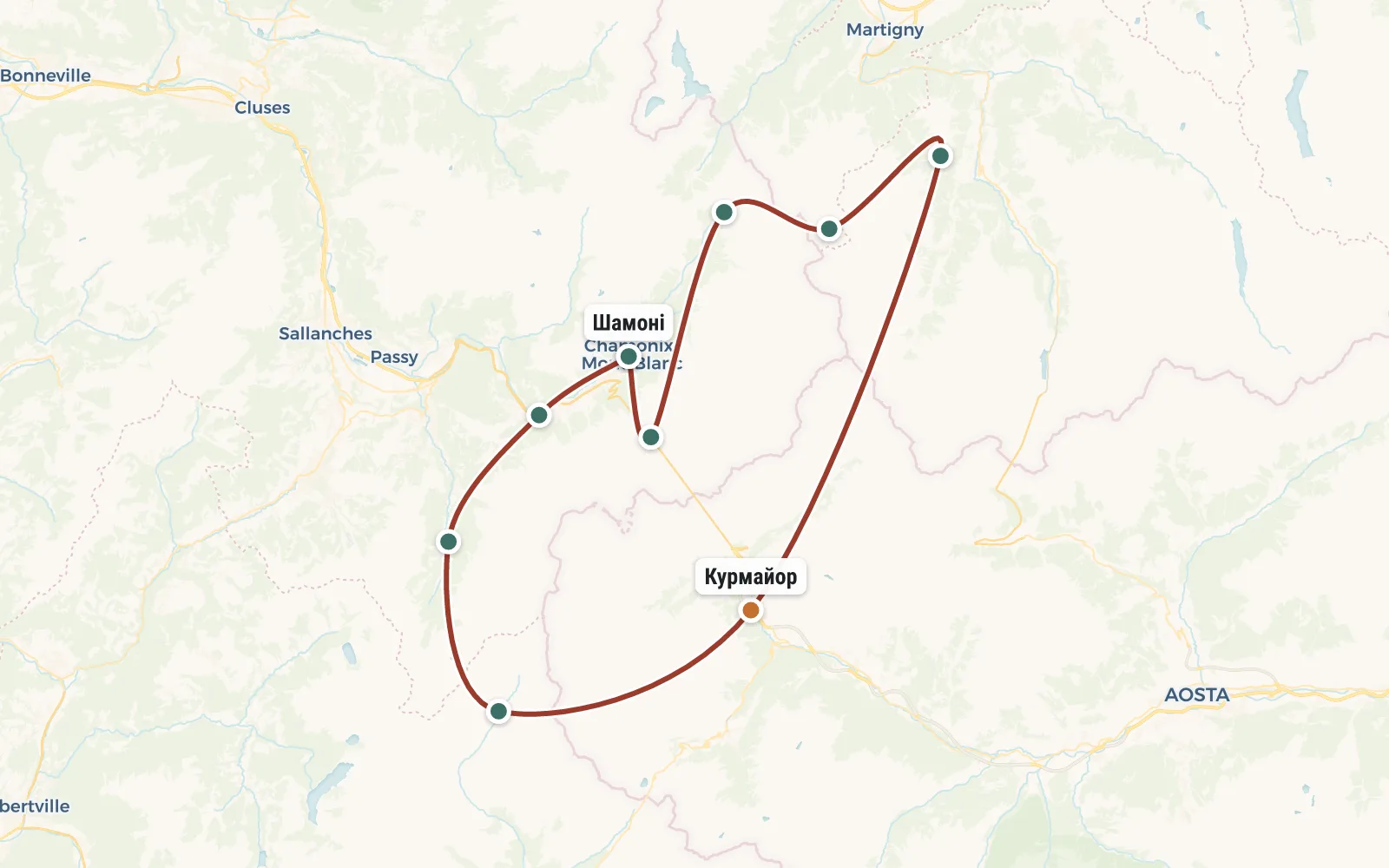
RouteRoute map
 Open the map →
The GPS track is not digitised yet, the line is approximate (by key points).
Along the trailWhat you will see


Day by dayItinerary
1 Day 1. Chamonix.
Group gathering in Chamonix (France), at a campsite in the center of the village. You can get to Chamonix by bus from Geneva (26 euros, 1.5 hours) or Milan (34 euros, 5 hours). Estimated collection time is 18:00. If you arrive earlier, you can walk around the city, buy more equipment, or take the cable car to one of the neighboring peaks.

2 Day 2. Les Ouges, Col de Tricot pass, Les Contamines-Montjoie.
We go by bus to the neighboring village of Les-Uzhs (altitude 990 m). On the cable car for 16 euros we go up to the Bellevue pass (1801 m). Here we cross the branch of the "Tramway du Mont Blanc" and finally break away from civilization. We pass by the Bionnassay glacier to the Col de Tricot pass (2120 m). For the night we descend to the village of Les Contamines-Montjoie (camping).
Travel time: 7 hours. Distance: 14 km. Elevation gain: 500 m.

3 Day 3. Pass de la Croix du Bonhomme.
We buy more groceries and leave the town. In the first half of the day we gradually gain altitude moving along the bottom of a picturesque valley. Then, after the La Balme shelter (1700m), we begin to go around one of the spurs of Mont Blanc - Mount Têtes des Bellaval (2892 m). We have already left the forest zone, and there is only grass, stones and glaciers on the opposite slope. We pass the pass de la Croix du Bonhomme (2329 m). Very close to it there is a high-rise shelter, where we will spend the night (in tents or under a roof, as desired). Cold night.
Travel time: 10 hours. Distance: 12 km. Elevation gain: 1150 m.

4 Day 4. Lake Lac de Mya, "glacial" village of La Ville des Glaciers.
We return from the shelter to the pass, and from there we go up. The next pass with a height of about 2670 meters will open up a view of the La Ville des Glaciers valley. If the weather is good, along the way we will stop by the Lac de Mya lake (2400 m). After descending to La Ville de Glacier (1790 m), we do not stop, but walk a little further to the Mottets shelter (1870 m). We stop for the night relatively early.
Travel time: 5 hours. Distance: 10 km. Elevation gain: 300 m.

5 Day 5. Col de la Seigne (2516 m), Italy, Miage Glacier, Rifugio Maison Vieille
The relatively flat Col de la Seigne pass (2516 m) leads us through the spur of the Aiguille des Glaciers mountain (3816 m), beyond which Italy begins. We descend to the Elisabetta Soldini shelter (2197 m). In case of good weather, lunch at the Lago di Miage lake (2000 m) and lightly we go on a radial path to the Miage glacier. Then another small section of gentle descent and we set up camp at the Rifugio Maison Vieille shelter (1960 m).
Travel time: 8 hours. Distance: 16 km. Elevation gain: 600 m.

6 Day 6. Courmayeur, Grand Ferret pass, Switzerland, La Foulie.
We descend to the Italian town of Courmayeur (1150 m). Here we buy food for the second half of the trek around Mont Blanc and take a bus to the upper reaches of the Val Ferret valley. At the Arpnouva shelter (1789 m) we again harness our backpacks and begin the assault on the Col de Grand Ferret pass (2537 m). The border between Italy and Switzerland passes through this pass. To our left is Mont Dolent (3820 m), to our right is Grand Golliat (3237 m). And we only need to go forward - to the Swiss village of La Fouly (1590 m) with the long-awaited campsite.
Travel time: 9 hours. Distance: 15 km. Elevation gain: 800 m.

7 Day 7. Ferret Valley, Champe-Lac.
Believe it or not, most of the day we go down, not up. Almost a resort - relaxed trail, pine forest, picturesque villages. And only after the Issert station (1056 m) a slight climb begins. We go to Champe-Lac (1470 m). This is a beautiful village on the shore of a large lake.
Travel time: 8 hours. Distance: 16 km. Elevation gain: 500 m.

8 Day 8. Fenetre d'Arpette pass or Bovine pass.
Today we have a choice. If the weather is fine and you have a lot of strength, then you can take the Fenetre d’Arpette pass (2665 m) by storm. This is more than a kilometer of elevation gain - it will not be easy, but it will be an opportunity to take a photo of our stern faces against the backdrop of the harsh Glacier du Trient glacier. Or you can go around, through the forest, through the Bovine pass (1986 m). In any case, we descend for the night to the Swiss village of Trian (1280 m).
Travel time: 9 hours. Distance: 15 km. Elevation gain: 1300 m.

9 Day 9. Col de Balme pass, France.
The last pass on the hike around Mont Blanc is called Col de Balme (2195 m). He takes us back to France. From the pass we descend to Le Tour and spend the night at a campsite. If we arrive early, we can immediately leave by bus to Chamonix.
Travel time: 8 hours. Distance: 15 km. Elevation gain: 500 m.

10 Day 10. Chamonix, Aiguille du Midi.
We arrive by bus to Chamonix. In fact, the hike around Mont Blanc is completed, you can go home. But if you have another hour and a half of time and 60 Euros, then you can decorate our trip with a ride to the top of the Aiguille du Midi (3842 m) by cable car. Although we have been walking around for 10 days, we have never seen Mont Blanc from this angle :)
DetailsIncluded
- 🧭Instructor services
- 🍽Derivative nutrition
- 🎒Public equipment (burner, boilers, first aid kit, group awning)
Not included
- ✕Visa
- ✕Moving and flights (about 300 Euros)
- ✕Food in restaurants
- ✕Visiting paid attractions (cable cars, museums)
- ✕Accommodation in campsites and shelters (on average 10 Euros per day)
- ✕Medical insurance
Trip conditions
To participate in this tour you will need a full set of equipment - tent, mat, sleeping bag. Initially, it is assumed that all overnight stays will be in tents, on the territory of campsites and shelters. On average it costs 10 Euros per person per night. For this money you get the opportunity to use: a lawn (for setting up a tent), a toilet, a shower and an outlet (for charging equipment). It is likely that in case of bad weather you will want to spend the night not in a tent, but inside the shelter. It will cost from 20 to 50 Euros per person. Therefore, it is better to take money for housing with a reserve (for example, 300 Euros).
It is prohibited to burn fires in the Alps. We will cook on gasoline burners, which the instructor will take with us. We partially bring the products from home, and partially buy them locally. The instructor is again responsible for organizing this process.
The group leader reserves the right to make changes to the route in depending on the weather, condition of the participants and other factors.


